


Field Topography UTM free
คำอธิบายของField Topography UTM free
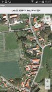
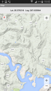
Topographical calculations for UTM & WGS84. Grid on the map.
Calculations in full or brief coordinates, in one or in the adjacent zones.
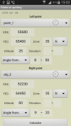
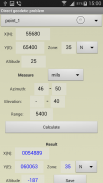
Rectangular coordinates in meters. Altitude, range in meters.
All angles on scale 64-00 or 60-00 (settings option on main screen).
In DGP and IGP angles are available in degrees - minutes – seconds.
GPS location in rectangular coordinates.
Azimuth of the Sun, the Polaris in specified time.
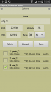
Maintain a list of objects that may be used in which the tasks (250). In free ver. - 3.
Read / write and append data from a file. The data file may edit/prepare a text editor, transfer methods available.
Google Maps, ArcGIS, MapBox, prepared ofline-atlases with markers points from the list (only with full coordinates).
Atlases in the format *.mbtiles can be created in SAS Planet, MobAC. Based on osmdroid.
UTM-Grid on the map.
When you touch the marker shows the number and name of the point.
When you touch the map shown rectangular coordinates of the location.
Maps are cached (accumulated) to work without a network.
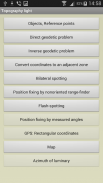
Tasks list:
Direct geodetic problem;
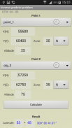
Inverse geodetic problem;
Convert coordinates to an adjacent zone;
Localizing with paired observation (readout from the base or directions);;
Binding undirected rangefinder (range up to 2 known points);
Binding by measured angles(between the left-middle and middle-right known points with anchor points);
Binding according to GPS (geodetic and rectangular);
Azimuth of luminary;
Localizing with a stopwatch (with the air temperature);
Map.
Settings:
- Maps ( Google / ArcGIS / MapBox / prepared offline-atlases);
- The scale of thousandths (60-00 , 64-00)
- Color style
- The type of map (topographic, satellite, hybrid)
- Type of marker points on the map
- Grid on the map (no , 1km , 2 km )
- Save data to a file, read / write and append data from a file.
The program is distributed "as is". Its use - discretion and responsibility of the user.
All tasks and all the features available in the full version.
การคำนวณภูมิประเทศสำหรับ UTM & WGS84 กริดบนแผนที่
การคำนวณในพิกัดเต็มหรือช่วงสั้น ๆ ในหนึ่งหรือในโซนที่อยู่ติดกัน
พิกัดสี่เหลี่ยมหน่วยเป็นเมตร ระดับความสูง, ระยะเป็นเมตร
ทุกมุมในสเกล 64-00 หรือ 60-00 (ตัวเลือกการตั้งค่าบนหน้าจอหลัก)
ในมุมมอง DGP และ IGP มีหน่วยเป็นองศา - นาที - วินาที
ตำแหน่ง GPS ในพิกัดสี่เหลี่ยม
Azimuth of the Sun, Polaris ในเวลาที่กำหนด
เก็บรักษารายการของวัตถุที่อาจใช้ในภารกิจ (250) ในเวอร์ชั่นฟรี - 3
อ่าน / เขียนและผนวกข้อมูลจากไฟล์ ไฟล์ข้อมูลอาจแก้ไข / เตรียมโปรแกรมแก้ไขข้อความวิธีการถ่ายโอนที่มีอยู่
Google Maps, ArcGIS, MapBox, จัดทำแผนที่ออนไลน์พร้อมจุดเครื่องหมายจากรายการ (เฉพาะพิกัดเต็มเท่านั้น)
Atlases ในรูปแบบ * .mbtiles สามารถสร้างขึ้นใน SAS Planet, MobAC ขึ้นอยู่กับ osmdroid
UTM-Grid บนแผนที่
เมื่อคุณสัมผัสเครื่องหมายแสดงจำนวนและชื่อของจุด
เมื่อคุณสัมผัสแผนที่แสดงพิกัดสี่เหลี่ยมของตำแหน่ง
แผนที่ถูกแคช (สะสม) เพื่อให้ทำงานโดยไม่มีเครือข่าย
รายการงาน:
ปัญหาจีโอเดติกโดยตรง
ปัญหาจีโอเดติกผกผัน
แปลงพิกัดเป็นโซนที่อยู่ติดกัน
การโลคัลไลซ์เซชันพร้อมการสังเกตแบบคู่ (การอ่านจากฐานหรือทิศทาง);
การจับระยะเรนจ์ไฟนอเรย์ทิศทาง (ช่วงสูงสุด 2 จุดที่รู้จัก)
ผูกพันตามมุมที่วัดได้ (ระหว่างจุดที่รู้จักกันด้านซ้ายกลางและกลางด้านขวากับจุดยึด);
ผูกพันตาม GPS (geodetic และสี่เหลี่ยม);
Azimuth แห่งแสงสว่าง;
การ จำกัด ตำแหน่งด้วยนาฬิกาจับเวลา (อุณหภูมิของอากาศ);
แผนที่.
การตั้งค่า:
- แผนที่ (Google / ArcGIS / MapBox / จัดทำแผนที่แบบออฟไลน์);
- ขนาดของหนึ่งในพัน (60-00, 64-00)
- สไตล์สี
- ประเภทของแผนที่ (ภูมิประเทศดาวเทียมไฮบริด)
- ประเภทของคะแนนเครื่องหมายบนแผนที่
- กริดบนแผนที่ (ไม่, 1 กม., 2 กม.)
- บันทึกข้อมูลลงในไฟล์อ่าน / เขียนและผนวกข้อมูลจากไฟล์
โปรแกรมมีการกระจาย "ตามสภาพ" การใช้ - ดุลยพินิจและความรับผิดชอบของผู้ใช้
งานทั้งหมดและคุณสมบัติทั้งหมดที่มีอยู่ในเวอร์ชันเต็ม
Field Topography UTM free - ข้อมูล APK
เวอร์ชั่น APK: 2.8.1แพ็คเกจ: nordsoft.topoUTM_lightเวอร์ชั่นล่าสุดของField Topography UTM free
เวอร์ชั่นอื่น


 3.94
3.94


แอปในประเภทเดียวกัน


